Tuesday 15 October 2019


16 Oct2019            
On the social media circulation of the Video of a
Cruise Ship Crossing the ‘Corinth Canal’

The video clip in circulation about the largest passenger ship yet to cross the Corinth canal came to me with a request to identify the place and more if possible because the video clip was being circulated without much of the information, that set me out to gather information and share!

Here are my friendly comments – mainly aimed at adding some more dimensions to it!


 courtesy - Google images


Map showing the location - 
courtesy ontheworldmap.com through Google searches

I also found on the internet some more contexts about this canal.
For those who don’t frequently travel in Europe, this is about the 1883 built Corinth canal in Greece near Athens in the Mediterranean Sea. It connects the Corinth Gulf to the Saronic Gulf (Greece). The passenger ship in the video - MS Braemar - made a history a few days ago by passing it as a large cruise ship crossing the canal.  The passengers on board could reach out and touch the sides of canal as per some news media, though that would be risky in my opinion. The on-line info about the canal says that it is just 24 meters wide at its narrowest point (pls see the photos taken from the internet). This man-made canal was completed in 1883. Being too narrow, it is mainly a tourist attraction now and not very useful for larger cargo ships. Its depth allows ships with only appx 24feet draft to navigate through it.
When made, this appx. 6km long canal saved about 185 nautical miles (362km appx) in sea distances.
Ship handling in such canals is very challenging because there is no quick 'refilling' of the displaced water from any other sources as the large ship passes through such a narrow canal. Therefore, the passing large ship cannot have the necessary hydro dynamics and stability for her to safely manoeuvre, that's why in this canal the smaller pulling boat is seen towing the bigger ship, the towing boat though small is powerful and is called a 'Tug boat'. As the larger ship finds her steering highly challenging, the Tug Boat gives pulls with the two ‘tug lines(ropes)’ from the bow of the passenger ship and helps her to counter any untowardly sharp swing and bang on the canal sides. It is possible that some of the ships would have some sort of fendering on her ship-sides to prevent damaging the ship's sides because it would be very difficult not to rub hard on the canal sides at some point, at least that seems so looking at some of the photos!
Thus, now out of major use, the canal joining two smaller seas around Greece seems to make good tourism opportunity for recently weakened economies.... of course, it also takes a shipowner to take such risks of possible damage to the ship and also the canal sides, as well as possible claims that would follow!
On merchant ships, it's the local expert mariners who help take the ships through the challenging waters, they are highly skilled and called the 'Marine Pilots' (much different in the role than the aeroplane Pilots); the ship's Captain himself/ herself remains responsible but doesn't always conn the ship in such specialised places himself/herself, unless he/she is a locally permitted expert himself/ herself.
Thanks to loads of history available on the internet (to be used with the discretion of course) I was also keen to figure out more about the idea of this canal being more than 2 centuries-old, to know more about many subsequent wars and war strategies used in the Eastern European area. There are references in the history of this canal that one of the Kings had launched the idea of a greased road with rollers that would transfer the ships across instead of the expensive project of digging the canal – that was abandoned many times before 1883 over the centuries. Similar ideas were said to have been actually deployed during the Byzantine and Ottoman wars for the control of Constantinople (Istanbul) and the Bosporus straits.  

The Corinth canal has Military references in World War II history too.

For tourism though, this is an extraordinary experience indeed! and it is possible with the tourism development by countries, cruise companies and the travel agencies! with the modern means of ship propulsion and steering plus the assistance of the towing Tug boat/s (pulling and controlling the ship through) the passengers would get a lifetime of thrilling experience. It is no wonder that the latest passage on the largest ship passing through it was fully booked and the next one will only be in 2021 as per the news.
It is heard that the canal often needs to be closed for maintenance.  
But it was not all, the rail-link that was made in 1988 at the sea level makes the passage possible, the tracks submerge to the depths of appx.8 meters to allow ships to pass as per this link https://www.amusingplanet.com/2013/09/submersible-bridges-at-corinth-canal.html

It also explains the draft restrictions on the passing ships! These rail bridges at sea level are the engineering marvel as well!


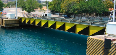
One of the submersible Corinth rail bridges (courtesy Google images on the internet)


 Taking a large ship through a very narrow waterway or a canal needs assistance from the powerful 'Tug Boats'

For those interested in  the Coastal Engineering studies this link may be found informative <<<<< https://www.witpress.com/Secure/elibrary/papers/CE05/CE05028FU.pdf
Boundary element slope instability modeling of Corinth Canal, Greece due to nearby fault activation G.-A. Tselentis & F. Gkika Seismological Laboratory, University of Patras, Greece >>>>>

For the recent Military references the Amazon.com link on Google may be interesting too


In the era of social media dominance – it gets very interesting to bring together so many factors we may think of when someone well-meaning shares information as that of the Corinth Canal crossing by the biggest cruise ship yet !! And the online references at your finger tips makes it easy to put together your thoughts and memories that the shared clip or quote triggers!!

-          - Capt. U.S. Gogate

Saturday 5 October 2019


The Mariner's View on the Trees Felling at Aarye Mumbai

There is much political and social storm with pro-and-anti Trees felling stands taken by citizens privately and publicly, individually & collectively in Mumbai's suburb. Some of the young demonstrators have compromised their CVs too by being charged with rioting for participating in the demonstrations.

It's about the land being cleared for a Metro Train Depot that stands on a wooded area and is adored by many city dwellers. 

Understandably the issue went to the court and the court verdict came in favour of the development - meaning trees felling on the designated area for the Metro Train Depot.

Being a professionally trained incident investigator and being seriously committed to the environmentally protecting the seas and oceans for over 4 decades (contrary to the popular belief that ships deliberately pollute the seas) as a seagoing professional I have a simple view as below: -

Who in the first place allocated this land to the Metro Depot project, knowing very well that it was a thickly wooded extension of the National Park?

Screaming against anyone else from the architects to the woodcutters or the courts to the administrations or the demonstrators to the police force is of little use. Isn't the root cause in the first place is the person/s who even dared to come up with the idea of cutting and levelling a centuries-old wooded area - technically the rest of the people are 'just doing their jobs'  and Yes! shouldn't the demonstrators while acknowledging their love and emotions, should also know by now that the environmental watchdogs must be non-political, unbiased and should be working from the conception of such projects that endanger the ecology in itself?

Below are the shared Links for the History of Mumbai Metro Planning & current news, - (courtesy news18 media, Wikipedia & 'Google')


-          Capt. U.S. Gogate
06Oct2019

Sunday 22 September 2019


What it means to be Grey Listed as a Flag state (shipping)?

22 September 2019

A new list of White, Black and Grey lists of ‘flag states’ came in force from 01July2019 and will remain in force till 30June2020. The ships flying the ‘Flags’ of the Black and Grey Lists will be subjected to greater scrutiny due to their internationally declared sub-standard operating levels.

Such a black or Grey listed status not only reflects very poorly on the crews and conditions of the ships flying those flags but also severely reflects on the way their owners operate them, worse still is that it also speaks poorly about their flag administrations.After all who will want ships that are poor in maintaining the operating standards of safety, security and pollution prevention to dock in their harbours?  and who would want to hire them for their transportation requirements?

Note for general knowledge of those not connected with the international shipping in general: Merchant ships are ‘flagged’ under various countries’ flags for the sake of their being properly regulated and governed. When a ship is not flagged, she would stand as a ‘rogue’ ship.
When a port receives a number of ships at its port facilities the port state wants the ships to follow the regulations and standards set out by IMO (International Maritime Organization which is the United Nations specialized agency with responsibility for the safety and security of shipping and the prevention of marine and atmospheric pollution by ships.) and Industry Best practices. Because those standards, in turn, assure the safety of the ports and waters of the host port state country.  
When ships of a Flag state are failing to follow these operating standards it is Black or Grey Listed by the name of that country.  
There are many chances that are given to the ships and their flag states to save themselves from falling into the Black or Grey lists that are maintained by multiple groups of the Port States. This is achieved by the port states by directly inspecting the ships calling their ports and also by gathering the statistics and data about the ships’ performances in other port states in the world.
The latest Table as well as the criteria used can be found in the links given below (courtesy Paris MOU and ICS): -


It is imperative that the flag states take immediate steps to change this status not only for their own reputation but also for the sake of the safety at sea and the protection of the environment in general.

The steps may range from a serious introspection of what went wrong in spite of several early warnings as well as warning signs The commercial data as well as the shipboard micro-management data of the performances, competencies of the ships’ officers & crews, shore management standards, real commitments of the business owners and managers and that of the Flag State Administrations themselves will need to be hauled up, revisited and repaired.

Such Black and Grey lists also warn the international traders about the dangers of associating with the ships flying the black/grey listed flags included in the Black and Grey Lists. 

While the ships in the White list assure of the good standards of compliance with the International rules, regulations and standards set out for the seas by IMO (IMO being the UN specialised agency for the Maritime matters.)

No Maritime Nation who is also a Flag State would ever wish to find its name listed in the Black or a Greylists. And demanding their actions to haul themselves out of such lists seems to be the very objective of these lists that warrant immediate constructive actions by those flag states.


-Capt. U.S.Gogate-       E N D -